Carrizo Badlands
by TourGuideTimLocation: Anza-Borrego Desert (102 Miles / 2 Hours East of Downtown San Diego)
Best Time to Visit: September – May
Cost: None
Features: Fossils over a Million Years Old; Caves; Hiking; Scenic Vistas
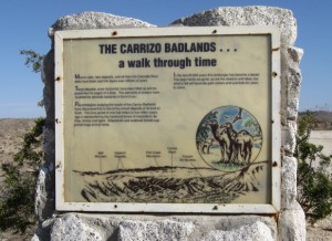
 Highlights for Carrizo Badlands: Five million years ago, the Carrizo Badlands were under the northern reaches of the Gulf of California. As silt from the Colorado River filled in and cut-off the northern reaches from its source of water, the Carrizo Badlands became a lush grassland. The area became home to mastodons, sabre-tooth tigers, camels, and zebras. However, as tectonic plates shifted and the mountains rose to the west, the area eventually became today’s desert. (You can learn more about the formation of the Anza-Borrego Desert in All the Wild and Lonely Places: Journeys In A Desert Landscape by Lawrence Hogue. There is a whole chapter dedicated to the Carrizo Badlands.)
This desert landscape has become one of the world’s best paleontology hot spots, filled with fossils left from previous eras. It also provides visitors a prime example of a shifting landscape. (Warning – The shifting landscape requires special precaution from visitors. Respect the power of nature in this remote terrain, including eroding cliffs, flash floods, and earthquakes.)
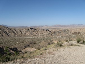
 Drive-By Visitors – If you want to stay on the main two-lane road, S-2, there is a lookout point just south of mile marker 52. Here, you can enjoy views of the diverse landscape that has been shaped over millions of years. Although this is a remote location for just a drive-by, some visitors include it as part of their trip to other attractions along the S-2 such as Agua Caliente Hot Springs and Vallecito Stage Coach Station or make a point to pass through this area on their way to Borrego Springs or the Anza-Borrego Desert State Park Visitors Center.
Hiking – As noted earlier, the surrounding area offers the most diverse desert landscape in the world. For detailed information on long hiking trails in the Carrizo Badlands, get Afoot & Afield in San Diego County by Jerry Schad. It includes information on whether you need a 4WD Vehicle, where to start, views not to miss, and when to watch out for dangers. For those who want shorter, easier trails, visit the Agua Caliente Hot Springs, which is a County Park.
Mud-Caves – For the more adventurous types, you will find caves to explore throughout the area. This should only be attempted by those who have no aversion to risk. There is no established park or tours where you can explore caves. If you would like to learn more, visit the DesertUSA web site where you can obtain more details and watch video clips.
Camping – You are allowed to set-up a tent anywhere in the Anza-Borrego Desert State Park. (Read more about setting up free open camp sites.) Established campgrounds and amenities are available 13 miles to the north on S-2 at the Agua Caliente Hot Springs.
Video – Get a glimpse of the Carrizo Badlands in this video. However, be aware that this video does not adequately capture the beauty and serenity of the desert in San Diego.
Correction: I meant to say “Mexico’s Gulf of California” rather than “Gulf of Mexico” in the video.
Information on Visiting the Carrizo Badlands
Directions from Google Maps to the Carrizo Badlands off of Sweeney Pass Road (S-2). This map takes you to the nearby Canyon Sin Nombre hiking trail. The Carrizzo Badlands Overlook is on S-2, a few hundred feet south of the turn-off for this hiking trail and just south of mile marker 52. (Keep an eye out for flash floods.) The Carrizo Badlands are 53 miles south of Borrego Springs and about 11 miles north of highway I-8. If you use highway I-8 from San Diego, you will cross Border Patrol checkpoints on both I-8 and S-2. Don’t worry. You have not left the country and there is rarely a delay.
Traffic – Listen for Strong Santa Ana Winds in the weather forecast. On occasion (usually limited to the fall and winter months), the winds may be strong enough that the I-8 is shut down eastward to the Desert. If you take a route through the mountains near Julian, keep an eye out for possible mountain snow in the forecast, when tire chains may be required to get through the mountains. There is very little traffic once you reach the desert. Be sure to travel with a full tank of gas since you will be going into a remote area.
Transit – There are no transit options that provide regular service into the desert.
Weather – The Desert’s high temperatures average over 100 degrees from June through September. Most tourists visit during the winter months when you still need to bring a lot of water, even if you are not planning on any strenuous activity. (Learn more about weather in the San Diego Desert and check the current Weather Forecast for the San Diego Mountains and Desert.)
Related Attractions – Visit our page on Borrego Springs to learn about viewing life-size models of the ancient animals that used to roam the area. You may also be interested in visiting the Borrego Badlands, which is east of Borrego Springs, and also offers spectacular views of the desert landscape.
Find More Attractions with Similar Themes or Location: Desert Adventure, Hiking, Parks - Local, State & National, Scenic Views, Vallecito / Southern Desert |

 Print the San Diego Map
 Print the La Jolla Map


 San Diego Attractions on Twitter